To see wonderful scenery, sample a slice of Appalachian Mountain life, and enjoy a slower pace, nothing can beat driving the Blue Ridge Parkway. Opened in June of 1936, the Blue Ridge Parkway covers 469 miles of the Blue Ridge Mountain portion of the Appalachian Mountains. It is designated an All-American Road as well as a National Parkway, and is visited more often each year than any of our National Park units.
Driving the Blue Ridge Parkway from North to South
The driving speed limit is 45 miles per hour or less, so make up your mind that you will be taking your time on this drive. Please also note that the Parkway is not maintained in winter, so portions of it will be closed in bad weather. Begin at the entry point near the Shenandoah National Park at Afton, Virginia, and travel southward, in the direction of Great Smoky Mountains National Park in North Carolina. Explore the many pull offs along the Parkway, and consider visiting some of the towns and cities along the way, to make your drive full and fulfilling.
Blue Ridge Parkway Mile 0
First, begin your drive at Afton, Virginia, a small town surrounded by vineyards you can tour. The town is also home to the spooky and impressive 1912 Swannanoa Palace. Set off down the Blue Ridge Parkway at Mile 0, Rockfish Gap. When you reach Mile 6.1, park and take the hiking trail to The Rocks at Humpback Rock, where you will find a group of authentic Appalachian farm buildings. Whetstone Ridge at Mile 29, is named for the fine-grained sharpening stones that could be found here.
At Mile 34.4, Yankee Horse Ridge, follow the reconstructed spur of an old logging railroad to Wigwam Falls. Stop at Mile 63.8 where the James River and Kanawha Canal’s footbridge leads to the restored canal locks and exhibits; take the self-guided trail along the river bluff. See mountain laurel and rhododendron in bloom in season at Mile 71’s Onion Mountain’s short loop trail. At Mile 83.4 take the mile-and-a-half loop trail to view Fallingwater Cascades.
 Linn Cove Viaduct. Part of the Blue Ridge Parkway
Blue Ridge Parkway Mile 84
Between Miles 84 and 87 you can see the Peaks of Otter, three mountain peaks that have been notable landmarks for hundreds of years. Next, take the shuttle bus up to Sharp Top. You can exit the parkway at Mile 86 and explore the small town wonders of Bedford, which looks amazingly similar to the town in the “Back to the Future” movies. Bedford is home to the National D-Day Memorial. Take a short stroll at Mile 114.9 to view the Roanoke River Gorge. You can follow a one-way 4-mile loop road at Mile 120.4 along steep grades to cross over Roanoke Mountain. Or just continue on to Mile 129.6 where the Roanoke Valley Overlook gives a view of Roanoke, Virginia, the largest community along the parkway.
When you reach mile marker 165, pause for a visit to the town of Floyd, with its charming vibe. Floyd is a combination of old time Virginia farming and artist community. You will enjoy the dozens of shops, galleries, and restaurants. The stretch between Mile 167 and 174 known as Rocky Knob provides views of Rock Castle Gorge. Take the trail at Mile 176.1 to Mabry Mill, a sawmill, blacksmith shop, gristmill, and exhibits where costumed docents demonstrate mountain skills in summer and fall. Don’t miss the Poor Farmers Market – open year round – at Mile 178, for jams and jellies and their specialty, fried pies! The Mayberry Trading Post at Mile 180 is a vintage country store that offers a charming photo op, as well as apple butter, and hand crafted wooden bowls.
Blue Ridge Parkway Mile 189
At Mile 189.1 the Groundhog Mountain Overlook and picnic area has structures demonstrating the history and heritage of early pioneer life, and an observation tower. The Aunt Orelena Puckett Cabin Exhibit is at Mile 189.9; it was the home of an area midwife who helped deliver more than a thousand babies, and never lost a mother or a child. Mile 213 is the Blue Ridge Music Center near the town of Galax, is open May through October. Enjoy concerts, music demonstrations, and a museum highlighting all things musical, especially old time music. Listen and learn about the national significance of the Blue Ridge Mountain musical heritage.
Next, the Blue Ridge Parkway crosses into North Carolina at mile 216.9. At Mile 217.5 you can visit Cumberland Knob, at an elevation of 2,885 feet; with its parkway recreation area. Fox Hunters Paradise, at Mile 218.6, provides a short walking path, to a spot where hunters could listen to their hounds baying in the valley below, and its beautiful view. Stop at Mile 238.5, to see the Brinegar Cabin, dating back to 1880.
Blue Ridge Parkway Mile 238
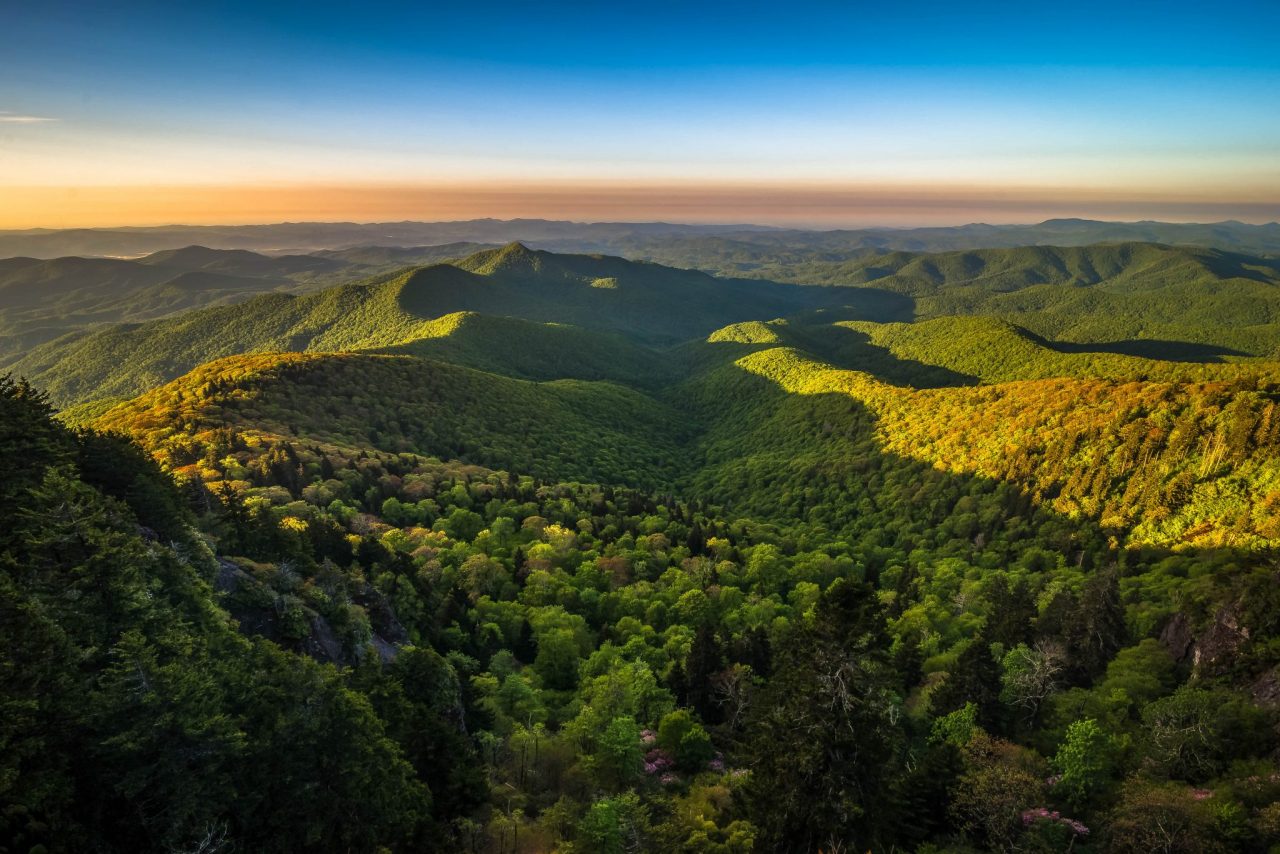 Warm Blue Ridge Mountain Sunrise
Doughton Park at Mile 238.5 to 244.7, is the largest recreation area the National Park Service manages on the Blue Ridge Parkway; it was named for Congressman Robert L. Doughton, a supporter of the parkway. The park has many miles of hiking trails. At 258.6 shop at “Sally Mae’s on the Parkway” in the Northwest Trading Post, featuring Hand Made in The USA products with food and drinks in a magical historic venue. offers crafts from North Carolina’s northwestern counties. At Mile 272 E. B. Jeffress Park has a self-guided loop trail to the Cascades waterfall, a short trail with a small wooden bridge and some stone staircases to view the falls. another trail starting here ends up at an old cabin and church.
Next, at Mile 285.1 stop to see Daniel Boone’s Trace, which Boone blazed to the West, crosses near here, near Boone. Did you know that Daniel Boone didn’t actually like coonskin caps? He wore a felt cap instead. You can also visit the city of Boone, nearby. Be sure to visit the Moses H. Cone Memorial Park at Mile 292-295; the main feature is Flat Top Manor, the former house of Moses H. Cone. It is now the Parkway Craft Center, filled with handmade items of distinguished interest. All of the artisans belong to the Southern Highland Craft Guild.
Blue Ridge Parkway Mile 304
Continue along the Linn Cove Viaduct, at Mile 304. This final portion of the parkway to be completed, skirts the side of Grandfather Mountain. A visitor center is located nearby and provides access to a trail under the viaduct. At Mile 305.2, Beacon Heights is a short one-mile roundtrip hike with spectacular views from several rock platforms to explore. Mile 308.3, Flat Rock, offers views of Grandfather Mountain. At Mile 316.3 take the trail to see dramatic Linville Falls and the bold rock cliffs of Linville Gorge. For locally grown heirloom apples, visit the Orchard at Alta Pass at Mile 328. Stop at Mile 331 for the Museum of North Carolina Minerals. This Museum is free, and It gives an overview of mining and mineralogy. Kids will love it. For a taste sensation, go just a few miles north to Spruce Pine, and have a meal at the Knife & Fork.
Most noteworthy, at Mile 339.5 see Crabtree Meadows & Crabtree Falls, among the tallest falls east of the Mississippi. The 70-foot waterfall can be reached by a 2.5-mile loop trail to a wooden bridge that crosses the river just below the falls. Leave the parkway at Mile 355.4 and follow NC 128, to see Mount Mitchell State Park the highest point east of the Mississippi.
Blue Ridge Parkway Mile 382
The Folk Art Center at Mile 382 is the main source for goods created by the Southern Highland Craft Guild. Shop and browse traditional and contemporary crafts of Appalachian. At Mile 384 The Blue Ridge Parkway Visitor Center is the newest attraction along the Parkway. The building houses a 70-seat theater showing an award-winning 24-minute film about the region. There are several exhibits, including a 22-foot interactive map showing all of the Blue Ridge Parkway. Visit the Mount Pisgah Inn Resort for delicious meals and lodging at 5,000 feet, at Mile 408.6. The inn is closed in the winter.
Next, at Mile 420.2 the Shining Rock Wilderness is the largest wilderness area in North Carolina. See extensive views at Mile 420.2 at Black Balsam Knob. Devil’s Courthouse’s a rough open mountaintop steeped in Cherokee lore, with a rock “face” peering out of the tree line. Devil’s Courthouse is 5,720 feet high at the peak. The half mile hike to see the views and alpine plants can be considered strenuous. Keep inside the overlook area and don’t go out on the rocks at the top, because there’s a Peregrine Falcons in that area. At Mile 451.2 Waterrock Knob offers panoramic views of the Great Smoky Mountains.
Blue Ridge Parkway Mile 469
Conclude your drive at Mile 469, where it meets U.S. 441 in the Great Smoky Mountains National Park and the Cherokee Reservation near Cherokee, North Carolina.


